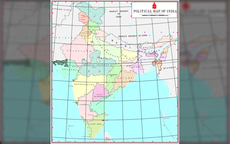
After discontinuing Special Status which was covered to Jammu and Kashmir Article 370 on August 5, 2021 the Union Ministry of Home Affairs has released New map of the Indian States and Union Territories. As Union Territories of Jammu and Kashmir and Ladakh formally coming into existence, Now India has 28 States and 8 Union Territories. Here is the List of States, UTs and their Administrative Details.
India has 28 States and 8 Union Territories.
Schools360 Team has gathered Important Information Regarding Indian States and UT’s which will be useful for All Competitive Examinations, Sarkari Naukri Recruitment Interviews etc.,
About India, a Union of States
India, a union of states, is a Sovereign, Secular, Democratic Republic with a Parliamentary system of Government. The President is the constitutional head of the Executive of the Union. In the states, the Governor, as the representative of the President, is the head of the Executive. The system of government in states closely resembles that of the Union. There are 28 states and 8 Union territories in the country. Union Territories are administered by the President through an Administrator appointed by him/her. From the largest to the smallest, each State/UT of India has a unique demography, history and culture, dress, festivals, language etc.
28 States and Capitals of India (Updated)
| State | Administrative Capital | Area in Sq.KM | Official Language | Total Districts |
| Andhra Pradesh | Amaravati | 1,60,200 | Telugu | 13 |
| Arunachal Pradesh | Itanagar | 83743 | English | 25 |
| Assam | Dispur | 78438 | Assamese | 33 |
| Bihar | Patna | 94163 | Hindi | 38 |
| Chhattisgarh | Naya Raipur | 1,35,192 | Chhattisgarhi | 27 |
| Goa | Panaji | 3702 | Konkani | 2 |
| Gujarat | Gandhinagar | 1,96,244 | Gujarati | 33 |
| Haryana | Chandigarh | 44212 | Haryanvi | 22 |
| Himachal Pradesh | Shimla | 55673 | Hindi | 12 |
| Jharkhand | Ranchi | 79716 | Hindi | 24 |
| Karnataka | Bangalore | 1,91,791 | Kannada | 30 |
| Kerala | Thiruvanantha- puram | 38852 | Malayalam | 14 |
| Madhya Pradesh | Bhopal | 3,08,252 | Hindi | 52 |
| Maharashtra | Mumbai | 3,07,713 | Marathi | 36 |
| Manipur | Imphal | 22327 | Meiteilon (Manipuri) | 16 |
| Meghalaya | Shillong | 22429 | English | 11 |
| Mizoram | Aizawl | 21081 | Mizo | 8 |
| Nagaland | Kohima | 16579 | English | 12 |
| Odisha | Bhubaneswar | 1,55,707 | Oriya | 30 |
| Punjab | Chandigarh | 50362 | Punjabi | 22 |
| Rajasthan | Jaipur | 3,42,239 | Hindi | 33 |
| Sikkim | Gangtok | 7096 | Nepali | 4 |
| Tamil Nadu | Chennai | 1,30,060 | Tamil | 37 |
| Telangana | Hyderabad | 114840 | Telugu, Urdu | 33 |
| Tripura | Agartala | 10486 | Bengali And Kokborok | 8 |
| Uttar Pradesh | Lucknow | 2,40,928 | Hindi | 75 |
| Uttarakhand | Dehradun, Gairsain (Summer) | 53483 | Hindi | 13 |
| West Bengal | Kolkata | 88752 | Bengali | 23 |
8 Union Territories and Capitals Updated List
| Union Territory | Administrative Capital | Area in Sq.KM | Official Language | Administratve Divisions |
| Andaman and Nicobar Islands | Port Blair | 8249 | English | 3 |
| Chandigarh | Chandigarh | 114 | Punjabi | 1 |
| Dadra Nagar Haveli and | Daman | 603 | Konkani, Gujarati, Hindi | 3 |
| Delhi | New Delhi | 1483 | Hindi, Punjabi and Urdu | 11 |
| Jammu and Kashmir | Srinagar (Summer), Jammu (Winter) | 20 | ||
| Ladakh | Leh | Ladakhi | 2 | |
| Lakshadweep | Kavaratti | 30 | English | 1 |
| Puducherry | Puducherry | 490 | Tamil,English | 4 |
New Map of Indian States and UT
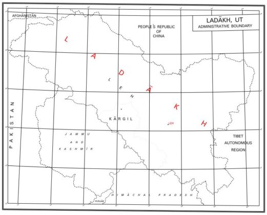
New Map of Ladakh and its Administrative Boundary
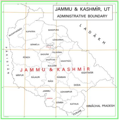
Jammu & Kashmir UT Map – Administrative Boundary


